 |
Dangerous vs navigable sides of a storm by David Burch |
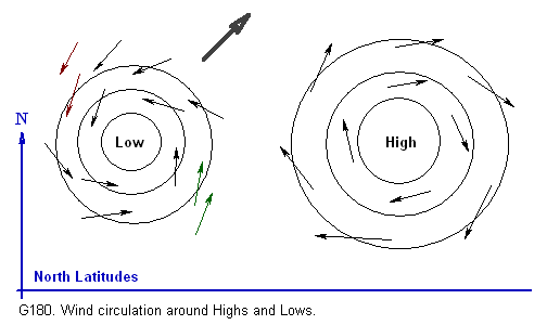
Most storms are asymmetric to some extent, having conditions more severe on one side than the other. This is true of most storms, but when it comes to practical matters of what we are going to do about it, the subject is pretty much restricted to dealing with tropical storms — because they are relatively small in surface area and can in some cases be maneuvered around. It would be very rare indeed that any smaller vessel could maneuver to one side or the other of a North Pacific storm spread a thousand miles across the ocean. On the other hand, modem weather routing services with good long range forecasting and excellent communications can direct the routes of faster deep sea vessels to avoid the worst conditions. This type of routing could even be more generally useful with these routing could even be more generally useful with these larger extratropical storms than they are with tropical storms since the latter have a much less predictable long term track. Weather routing is discussed in ART-9. In the NH, conditions on the right-hand side of storms (called the "dangerous" side or semicircle) are more severe than those on their left-hand sides (called the "navigable' semicircle). In the SH, the situation is reversed. There are several reasons that lead to these conditions, having to do with the wind speed, its direction relative to the storm's path, and to the sea state produced. In this note we take a brief look at these factors. In the NH, storm winds circulate counterclockwise around the center of a Low. Thus, when facing in the same direction the storm is moving, the left side has same direction the storm is moving, the left side has wind blowing aft, the right side has wind blowing forward (See G180). If the storm were stationary, the wind speed on either side would be about the same if we sailed into it. When it starts to move, however, this is no longer the case.
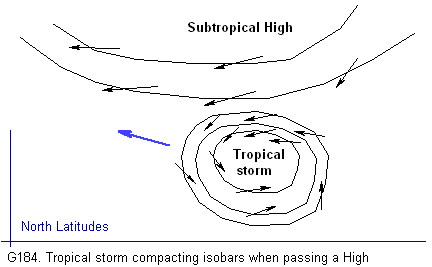
Consider for the moment, not a circulating storm, but just a cylinder of still air, the size of the storm. Then imagine this cylinder of air moving east at a speed of 20 knots. If this moving air passed over us, we would feel a west wind of 20 knots as it passed, regardless of what side of the cylinder we were on when it crossed. A 20-knot westerly, after all, is just air moving east at 20 knots. Now consider that this cylinder of air is a revolving storm with winds circulating at 30 knots — an easterly north of with winds circulating at 30 knots — an easterly north of the Low and a westerly south of the Low. While the storm remained stationary, there would be a 30-knot easterly north of the Low center, with a 30-knot westerly south of the center. When the storm starts to move at say, 20 knots, however, its own motion adds to the surface winds it carries with it. South of the Low, we get 30 +20. or 50 knots of westerly, whereas north of the Low we get 20 knots of westerly +30 knots of easterly, which leaves a 10-knot easterly. In other words, in the NH, a storm's motion adds wind to the right side (called the dangerous semicircle) and reduces the wind on the left side (called the navigable semicircle)—the vector addition of winds, however, is never quite so complete as indicated in this example. The flow pattern of the wind is more complex and under other influences. other influences. Another independent factor contributes to the strength of the wind on the right side. Tropical storms tend to move westward through the northern Tropics, which leaves the subtropical Highs on their right hand side. As the storms approach the isobar pattern around the Highs, their own isobars are compressed giving rise to stronger winds on the side closest to the High (see G184). This type of isobar compression is exactly what takes place in the case of a "lee trough" packed up against a stationary High. The same factor contributes to enhanced wind on the right of extratropica! Lows, since these move eastward over the tops of the Highs. See ART-25 for more on the motion of tropical storms.
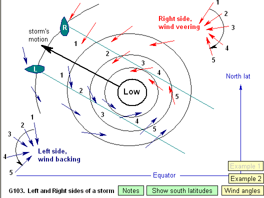
In the SH, winds circulate clockwise around Lows, so it is the left side that is the dangerous side due to the added wind of the storm's motion and also due to the compression caused by subtropical Highs. Note that in the SH, tropical storms also tend to move westward and somewhat poleward as in the NH. Likewise, extratropical Lows of the SH also pass poleward of the Highs. The two hemispheres are symmetric with regard to causes for increased wind on the dangerous sides of storms. The name "dangerous side," however, has as much or more to due with the direction of the wind as it does with its speed. When a storm approaches so as to leave you on its dangerous side, its increasing winds tend to push you into the path of the storm (north or south of the equator), whereas on the navigable side the building wind pushes you away from the path of a storm (see G103). Keeping in mind that tropical storms and hurricanes are often relatively small in size (see ART-25), this wind direction can be the dominant factor in your overall experience of the event. Recall that just some 80 to 100 miles from a typical hurricane center, storm winds could be down to 40 knots or so. Sailing against the wind in big seas on the dangerous side can mean no progress at all, versus accelerated progress away from it on the navigable side.
Still another factor is tied to typical paths of the storms themselves. They move generally westward (NH and SH) and then tend to curve poleward — rarely do they move toward the equator once formed. Hence the dangerous side is also the side the storm is likely to turn toward as it progresses. It is difficult to stress a tactical aspect of this issue, however, because, first, the motions are erratic and second it could wrongly imply some virtue in have a larger fetch. Waves built by tropical storms and hurricanes reach phenomenal heights, so any maneuver to avoid the worst of them by maneuvering to stay on the navigable side is crucial to the best handling of the situation. How we might be able to take any of this knowledge into account in negotiating specific situations, however, is another matter. This clearly depends on where we are relative to the storm, how big it is, and most important how fast we can move in the prevailing wind and seas. More discussion is presented in RES-6 on storm avoidance. From "Weather Trainer" by David Burch Visit blog to discuss this artilce |
home / about / yacht brokerage / yacht building / cruising / design / articles / blog / events / sails / resources / resources
mail to info@amariner.net |
|